
Attractions


Four Mile Road, Brooman NSW, Australia
The Great Grandmother Tree of Brooman, The World's Tallest Spotted Gum
Affectionately called ‘Big Spotty’, this ancient giant is accessible via a walk, bike ride or drive from the old town of Brooman. Nestled just off a ridgeline in a protected south-easterly position, this natural wonder will humble and ground you. She is a remarkable living feature of Brooman’s cultural heritage.
This is the world’s tallest known spotted gum — a magnificent forest sentinel, and well over 1500 years old according to experienced local timber cutters who observed that native eucalypts in this area grow more slowly with age, especially on hard, dry ridges where growth is far from linear — evoking a sense of what the once-open forests of this area looked like. It is now at risk from continued NSW government mismanagement in the form of forest fuel build-up. This is despite the fire patterns at Brooman during the Currowan bushfire, which largely circled around the private property area that had been culturally burnt in the immediate years before.
Towering 71 metres, with branches the girth of large trees and an 11.5-metre circumference, this ancient has witnessed at least 50 generations of people pass by. Locals revere her, and some of the old timber workers still recall the stories from the late 1800s when this and other old trees were simply too massive to fell.
This most significant mother tree was protected by the current owner and custodian of Brooman during the NSW government's 2019–20 Currowan megafires. Its biggest threat remains bureaucratic incompetence and insufficient conscious burning and fuel reduction in the surrounding state forests.
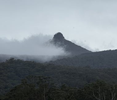


Pigeon House Mountain (Balgan), Pigeon House Walking Track, Yadboro NSW, Australia
Pigeon House Mountain (Balgan)
The Pigeon House Mountain (Balgan) walk is the most popular day walk on the South Coast. Less than 30 minutes' drive from Brooman, the view from the top is breathtaking. To the east, you look out to the Pacific Ocean, and on clear days, Conjola, Milton, Ulladulla, Bawley Point, Durras Mountain, Batemans Bay, and much further south to Gulaga Mountain. To the west, you look down over Yadboro, Byangee Walls, and out to Cooyoyo (The Castle). To the south-west lie the rugged coastal range peaks of Wirritin, Currockbilly, the Fault Line, and Mount Budawang. To the north, you look up the river to the Clyde River Gorge and out to Mount Bushwalker.
Located in the southern section of Morton National Park, not far from Ulladulla, the popular 5 km return walk starts with a steep ascent before it plateaus, then climbs the final slope to the ladders onto the peak itself. The traditional route is on the western side of the mountain from Longfellas Track, but it is now heavily overgrown due to mismanagement and the devastation caused by the NSW Government-created Currowan bushfire.
Respected local Elder Uncle Max Harrison — who was born at Bawley Point — called it “Balgan” — not Didthul nor “Tit hill”. It was the first mountain on the east coast to be named by Captain Cook, who called it Pigeon House due to its shape. Uncle Max used to joke that Cook “had been at sea so long he’d forgotten what a woman’s body looks like.” Traditionally, the mountain top is a men’s place. Balgan/Pigeon House is iconic up and down the South Coast and throughout Yuin Country, and remains a prominent part of the south coast identity for tens of thousands of locals today.
A must-do walk for stunning views, cultural depth, and adventure.
Shout-out to Cheryl Davison for her beautiful painting titled "Balgan"


The Castle, Byangee Walking Track, Yadboro NSW, Australia
The Castle (Cooyoyo) Walking Trail
The Castle is one of the more serious walks in Morton National Park, and gateway to the Shrouded Gods, Monolith Valley, Corang and spralling network of spectacular country. Views from the summit span Pigeon House Mountain (Balgan), Byangee Walls, Yadboro, the Clyde River Valley, the broader Budawangs, and the distant coast on clear days.
From Long Gully campground, it is roughly 8–10 hours return (or longer for most), with ~800 m ascent including exposed ‘tadpole tail’ scrambles near the summit. From the top it is roughly 700 m through scratchy Hakea to the southeast cliffline, overlooking Yadboro and the Clyde Valley.
Many camp at Cooyoyo Creek, though traditionally people camped in the caves at Monolith Valley. Overnight walkers explore Monolith Valley on Day 1 and summit The Castle (Cooyoyo) on Day 2 - with supplies you could easily spend days or longer in the area. The NSW Government's NPWS maintains few of the traditional old tracks and continues to block access with closures, minimal infrastructure and threatening signs. Local contractors have recently done some good track work on the main access and revamped the Cooyoyo Creek camping area.
If you're keen, prepare for off-track navigation, minimal to no signage, and patchy mobile reception. Rescues are common due to falls, slips, or disorientation. This is a beautiful and spectacular area, but self-reliance is essential.
Best in late autumn to early spring; avoid wet conditions — scrambles can turn treacherous. Requires excellent fitness, a head for heights, and solid navigation skills.


Pretty Beach NSW, Australia
Pretty Beach, Marramarang National Park
True to its name, Pretty Beach is a stunning South Coast gem. Once a free-wheeling summer camping hotspot, access is now managed and charged by NPWS. The hilltop car park and campground overlook Durras Mountain and the coastline south to Gulaga Mountain.
Popular in summer and holidays, spend a morning or afternoon exploring Pretty Beach and its southern shoreline. It’s the trailhead for Durras Mountain walks and the coastal path to Pebbly and Depot Beaches (part of the Murramarang South Coast Walk). Grab supplies or a bite at the Merry Beach café/shop or a nearby Kioloa café.
The entire area boasts beautiful beaches, bays, and top fishing and surfing spots.
Access is via Bawley Point, where you’ll find an IGA, bakery, chemist, newsagent, and bottle shop.


Depot Beach Rainforest walk, Depot Beach NSW, Australia
Depot Beach, Murramarang National Park
This is one of the South Coast’s most stunning beaches. Forested mountains spill onto the shore, where eastern grey kangaroos graze on grassy dunes amid small rocky islands, sandy and pebbly beaches, hidden bays, and turquoise waters.
Depot Beach itself is spectacular. The access road also leads to Pebbly Beach, Point Upright, and North Durras — perfect for a full day of exploring, swimming, and wildlife spotting.
From Depot Beach, the view north to Pebbly and Pretty Beaches frames the tree-clad Durras Mountain descending to the sea, with dramatic honeycomb rock formations carved by waves.
Allow 45 minutes' drive (or more, depending on traffic and stops) from Brooman.


River Road & Clyde River, Mogood NSW 2538
Shallow Crossing
Downstream from Brooman, where The River Road crosses the Clyde River, this scenic playground offers a flat concrete causeway/ford at the upper tidal limit of the river — always with water flowing except in extreme drought, when the upstream side can turn brackish.
Popular in summer for swimming, kayaking, fishing, and family fun. Swim upstream or downstream depending on the tide; build rock pools in the clear, cool water and wait for the tide to drop if you find it too deep to cross safely.
The crossing is impassable during floods and king tides. Shallow Crossing is a relaxing spot to enjoy the Clyde River’s natural beauty, surrounded by state forests and ideal for picnics or birdwatching. Follow The River Road downstream, cross Currowan Creek, and you’ll eventually reach the Kings Highway not far from Nelligen.


LOT 22 The River Rd, Mogood NSW 2538, Australia
Clyde River Berry Farm
Not far upstream from Shallow Crossing and downriver from Brooman, Clyde River Berry Farm invites you to drive through the forest hinterland and pick your own berries. Primarily growing blueberries for pick-your-own (open daily in December and January), they also sell at local farmers' markets. Other berries are available for pick-your-own, subject to seasonal variation. Don’t miss their delicious berry ice creams — always a hit with kids! They also sell farm-made jams and local honey.


Mogood lookout, Mogood NSW, Australia
Mogood Lookout, Clyde State Forest
A drive up to Mogood Lookout reveals 360° panoramic views of the Clyde River Valley. To the east you can see Brooman and, further east, the coastline. To the north lie Pigeon House Mountain and the dramatic Castle complex. To the west, across the Bimberamala River, rise the spectacular coastal ranges of Wirritin, Corrockabilly, the Fault Line, and Mount Budawang. To the south are Bolaro Mountain, Wondera, and in the far distance, Gulaga Mountain.
Mogood is a hidden gem in the Clyde State Forest area. It is accessible by 2WD or 4WD via Cattleman’s Fire Trail, which climbs steeply off Clyde Ridge Road. Numerous 4WD tracks branch out through the surrounding state forests and national parks from here.
Mobile reception is limited or nonexistent once you leave the ridge lines. Always check conditions before heading out, especially after rain — the river rises fast and can cut you off for days (or longer), and the clay roads can turn treacherous very quickly.

Old Blotchy Walking Track, Termeil NSW, Australia
Old Blotchy, Spotted Gum
Just 5 minutes off the Princes Highway between Ulladulla and Batemans Bay, in Murramarang National Park at Termeil, stands ‘Old Blotchy’ — an ancient spotted gum estimated at well over 1,500 years old (based on local observations of slow, non-linear growth) and still thriving.
Listed on the National Register of Big Trees and cherished locally, it measures 59 metres tall with a 30-metre crown spread, holding the record for the widest spotted gum by base circumference (approximately 10.7 metres). A perfect spot to ground and humble yourself — and less than 20 minutes' drive from Brooman.


Bawley Point NSW 2539, Australia
The Gantry, Bawley Point
A historic relic from Bawley Point’s timber milling era, the Gantry once loaded ships with milled timber destined for Sydney in the late 1800s–early 1900s. The original structure (one of the last remnants of the local sawmill, which burnt down in 1922) was lost to a devastating storm in June 2016, but a new one — rebuilt in 2016–2017 with funding from Terry Snow (of Willinga Park) and community support — preserves this legacy.
Now a popular fishing platform, it’s also a hub for swimming, scuba diving, surfing (nearby at Guillotines and the Point), and enjoying stunning coastal views.
Located at the southern end of Bawley Beach, it’s a short walk from shaded BBQs, a kids’ playground, and the Lake Willinga outlet.
A blend of history, beauty, and community — less than 25 minutes' drive from Brooman.
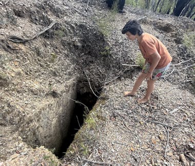


Mines Road, Mogood NSW, Australia
Mines Road Gold Diggins
Brooman lies within one of NSW’s historic goldfields, part of the broader Batemans Bay and South Coast region that saw rushes from the 1850s onward. Nearby historic mining towns include Nerriga, Mogo (home to some of the world’s purest gold nuggets), Moruya, Nerrigundah, Araluen and Majors Creek.
Locally, popular areas for recreational gold prospecting include Currowan Creek — south of Shallow Crossing — Bimberamala, and Mines Road, which runs between Clyde Ridge Road and the Wallaby Road/Lyons Road junction.
The junction of Mines Road and Mines Road South features numerous old mine shafts — some now bulldozed by National Parks, others fenced off or overgrown. A 4WD or AWD vehicle is recommended to access these areas. Exercise extreme caution on foot — watch for hidden hazards like unstable ground, collapsed shafts, or overgrown dangers.
These areas are a part of the local heritage, don't hurt yourself and give the government a justification to destroy them.

1295 The River Road, Brooman NSW, Australia
Ned Heycox Mother Tree
In the old sawmill town of Brooman is a memorial of sorts to the many old and precious trees that were not so fortunate during the 2019–20 Currowan bushfires. They were burnt over by the callous, incompetent and self-serving ‘go-slow’ tactics of the Forestry Corporation and other paid employees of the NSW State Government.
The current owner and custodian of Brooman bought a 16-tonne forestry skidder from Tasmania specifically to retrieve this 1,200+ year-old spotted gum and bring her to where she lies now. It was alive and standing on private property before the Forestry Corporation came uninvited onto his country with their bulldozers and literally burnt it over.
In memory of Ned Heycox, who was a timber man, previous custodian and early conservationist of Brooman. Ned used controlled fire (or cultural fire / cultural burning) to protect this and other very old trees, which he referred to as the “Mother Trees”.
There are still other ancient spotted gums and blue gums sprinkled around the forests of Brooman.


Meroo Head campground, Meroo Lookout Walking Track, Termeil NSW, Australia
Meroo Point and Meroo Lake
From Brooman, head to Termeil and north on the Princes Highway to reach Meroo National Park — a large forested headland accessed via unsealed dirt road (suitable for most vehicles in dry conditions). Meroo Lake lies immediately south of the Meroo car park (at the end of Meroo Point Road). Termeil Beach is not far to the north.
Short walking tracks from the car park lead to the headland, lake, and Termeil Beach. Walk south along the shore to Nuggan Point or north to Termeil Point and Sunburnt Beach.
Surrounded by spotted gum and mahogany coastal forests, this area is ideal for swimming, walking, surfing, fishing, whale watching or just hanging out.